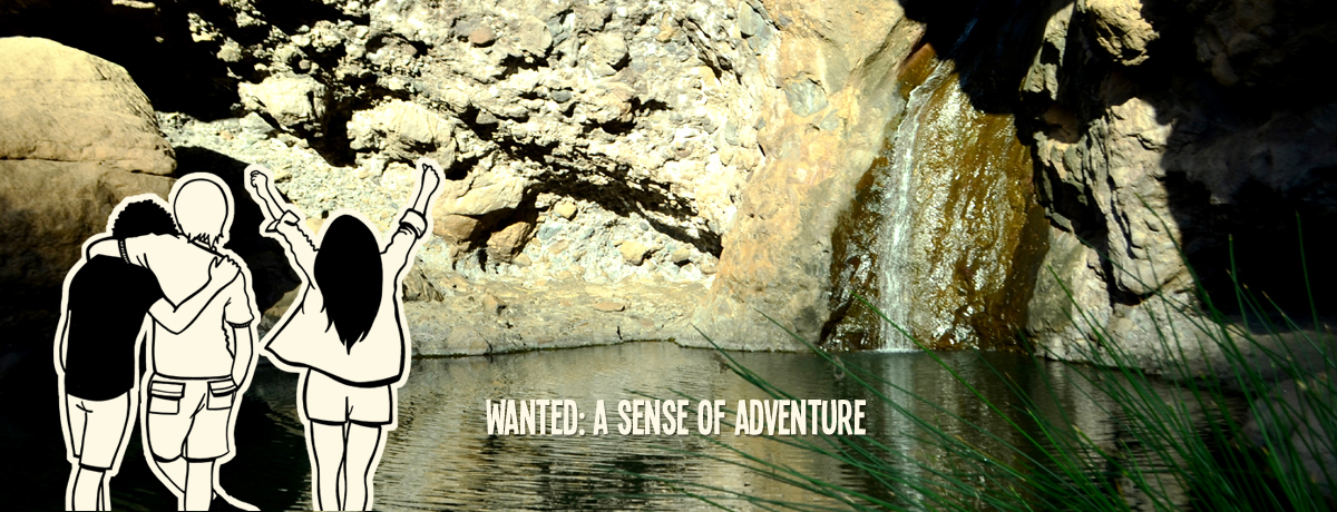
In the west of Gran Canaria lies a place where vertigo and the rush of life are soothed by a refreshing dip in fresh waters. That place is El Charco Azul.
It is a natural pool among cliffs, fed by a waterfall for most of the year. El Charco Azul gathers the waters rising from the mountains of Tirma and Tamadaba before they continue their course towards the Atlantic.
You can reach it from the village of El Risco, forty-nine kilometres from Las Palmas de Gran Canaria, and only fourteen kilometres from Agaete.

El Risco is a small hamlet, now home to around three hundred inhabitants, holding behind it one of the island’s hybrid treasures. One of those places open to enjoyment, a gem for explorers of unconventional spots.
Many hikers passing through this small settlement may make the mistake of underestimating El Risco, seeing it as merely a place to stop for a drink and rest from the curves of the road.
Yet this place holds much to discover. First, you will find the warm and traditional welcome of its people. Its streets seem to draw you in. Behind the neighbourhood, several trails lead into the mountains, inviting you to explore. It is here that the trail to Charco Azul begins.

Up through the ravine, shifting colours accompany the traveller’s steps. Its slopes are dotted with terraced farmland, palm groves and the occasional trickle of water. At the end of this short three-kilometre walk, we will have reached our destination. Before returning, many dare to take a dip in its waters.
Although the visit is pleasant at any time of year, the best months to come here are between January and May, especially in years when the rains have blessed the island. During the summer months, caution is needed as temperatures rise; carry plenty of water and, if there is no running stream, avoid bathing.
Before heading back, we look up and let ourselves be swayed by the ascent of its slopes, where the pine forests and the clouds offer an incredible farewell from one of the island’s most purifying corners.

From Las Palmas de Gran Canaria, take the GC-2 to reach the municipality of Agaete, then continue along the GC-200 towards La Aldea de San Nicolás for fifteen kilometres. From the south of the island, take the GC-1 to Mogán and continue along the GC-200 towards Agaete.

This is the westernmost district of the municipality, about half an hour from the town centre of Agaete. It has a distinctly agricultural and livestock-farming character. This small hamlet stands out for its agri-food businesses, such as goat’s cheese and yoghurt production, as well as for the growing development of rural tourism, with several traditional Canarian-style houses dedicated to this type of accommodation.
El Risco Beach is one of the largest wild beaches on the island. Located at the mouth of the ravine, barely a kilometre from the village, the coast is reached via a dirt track that descends towards the sea between low scrub. At the foot of the mountains lies a beach of rocks and black sand stretching almost four hundred metres, where sand and gravel were once extracted for construction. Care must be taken with the waves, as the currents in this area tend to be strong.
Nearby lies one of the most beautiful protected landscapes of Gran Canaria, valued for its geology, flora, fauna and archaeological riches. The place is crowned by its nudist beach, a charming cove blessed with stunning sunsets, very close to Agaete. Its palm groves, together with the volcanic black soil, the spectacular cliffs that surround it, and the distant view of Mount Teide crowning the neighbouring island, are a gift for the senses.
Agaete is the municipal capital to which this enclave belongs. Located at the foot of the Tamadaba Pine Forest, this area is defined by the harmony between sea and mountain. Most of its neighbourhoods are found near the Agaete Valley. Marked by a strong agricultural character, its ravines hold everything from tropical fruit and vineyards to a unique species of coffee. Closer to the sea, its beaches and harbour are also sites of great interest and value.
The Village of San Nicolás, a neighbouring municipality now linked to the district of El Risco by a tunnel, is the capital of the island’s westernmost region. This town has long been an important economic engine thanks to its activity, mainly tied to export agriculture and fishing.