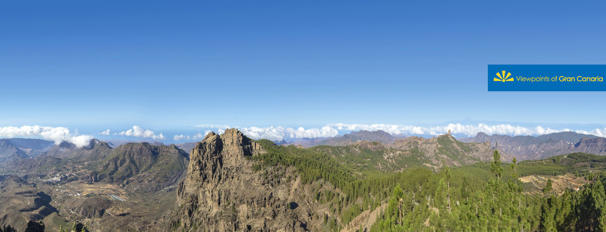
Right behind us, at the highest point of the island of Gran Canaria, the Morro de la Agujerada, at 1949 metres above sea level, we look out over the Teide mountain from the pinnacle of an immense triangle, located in the centre of the island, covering an area from the Macizo de Tamadaba, at the furthest point to the northwest, to the Macizo de Amurga, to the southeast, in a visual arch which cannot be covered in one go and accounts for almost half the round island.

An oasis of pines which were planted in the 1950s at Los Llanos de la Pez and Pargana, precedes the blue sea of the Antlantic Ocean. Between them stands a mountainous scenery marking out the island’s terrain. Within its folds sits Tejeda, at the foot of the Roque Nublo, which stands proudly like a timeless axis; La Aldea de San Nicolás and Mogán, down by the sea, while further south, Las Tirajanas.
Three enormous basins dominate the landscape from here, eroded over the centuries by water that has worn away the central summit since its formation in the Pliocene period, as well as materials strewn about by the later collapse of the Roque Nublo volcano.


A quote by the late 19th century French anthropologist René Verneau, defines the summit thus: “It is etched out in every sense by deep depressions and made pointy by volcanic peaks... It is such a tormented place, with its great black rocks and immense cracks that spill out in all directions, and would have an even wilder appearance if it weren’t almost completely covered by vegetation”.
This landscape holds great geographical landmarks such as the Roque Nublo, the Roque Bentayga, El Fraile, Llanos de la Pez y Pargana, also the Caldera de Tejeda and the Tirajana crater.
It owes its name to the proximity of three wells which were built at the beginning of the 17th century, with the aim of storing snow that had fallen in the winter. Two of them have been restored and are open to visitors.
This area forms part of the World Reserve of the Gran Canaria Biosphere, as declared by UNESCO on 29th June 2005.